


If You Believe in The Heliocentric Model, Then You Believe That The Nile River Flows Uphill for 532 Miles???

With a total length of approximately 4,130 miles between the region of Lake Victoria and the Mediterranean Sea, the Nile River is among the longest rivers on Earth. The Nile River flows from South to North through northeastern Africa, originating near Lake Victoria and emptying into the Mediterranean Sea on the coast of Egypt. Since half of that path, (2,065 miles), would be uphill, the other half being downhill, and if we grant The Heliocentric delusion where there is no up or down with a ball whizzing through a space vacuum, then that comes to approximately 532 miles (approximately 2,779,811 feet) of uphill curvature, and subsequently, water flowing uphill that distance.
Have you ever seen a river flow uphill? Of course, not. Water seeks its own level and so, it stays where it is as level, or flows downhill with any drop in elevation to attempt to seek its own level again. Water does not flow uphill, and especially not for 532 miles.
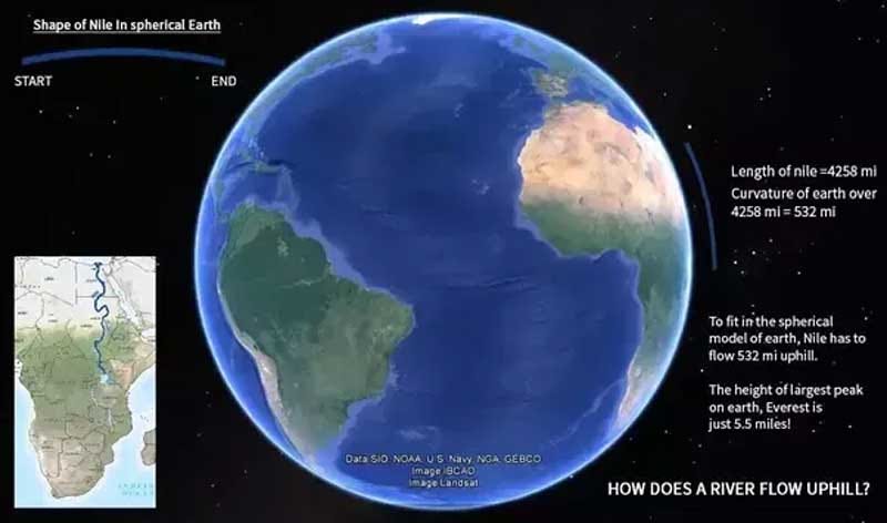
But, if you believe The Heliocentric Model is true, this is the insane situation into which you are buying. However, if you know you live on a plane, with various topological variation, (e.g., hills, mountains, canyons, etc…), then the path of The Nile River makes more sense. It’s simply obeying the natural physics of water to seek its own level.
Detractors will try to insert magical imaginary Gravity into the equation by saying that Gravity is a real and significant ingredient in determining a river’s course. But actually, contrasting elevations are all that is required to explain river flow, (i.e., either above or below sea level). All water seeks sea level, unless impeded or obstructed by some solid and impermeable barrier. Notice it is called sea level, not sea curve.

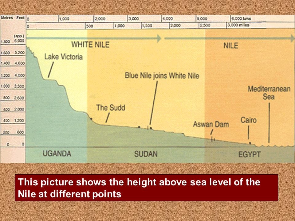
Source Elevation:
The Nile River begins at Lake Victoria, which is situated at a significant elevation above sea level.
Flow Direction:
As the river flows north towards the Mediterranean Sea, it gradually descends in elevation.
Delta Formation:
Because the Nile is above sea level when it reaches the Mediterranean, it forms a delta at its mouth.
Eric Dubay Discusses The Impossibility of The Mississippi and Nile Rivers Flowing Uphill Over The Imaginary Curvature of The Earth
In The Heliocentric Model, The Mississippi River System Flows Uphill
The Mississippi River System, also referred to as the Western Rivers, is a mostly riverine network of the United States which includes the Mississippi River and connecting waterways. The Mississippi River is the largest drainage basin in the United States. In the United States, the Mississippi drains about fifty-nine percent of the country's rivers.
From the perspective of natural geography and hydrology, the system consists of the Mississippi River itself and its numerous natural tributaries and distributaries. The major tributaries are the Arkansas, Illinois, Missouri, Ohio and Red rivers. Given their flow volumes, major Ohio River tributaries like the Allegheny, Tennessee, and Wabash rivers are considered important tributaries to the Mississippi system. Before the Mississippi River reaches the Gulf of Mexico, it runs into its distributary, the Atchafalaya River.
Eric Dubay’s Commentary on The Mississippi River:
“The natural physics of water is to find and maintain its level. If Earth were a giant sphere tilted, wobbling and hurdling through infinite space then truly flat, consistently level surfaces would not exist here. But since Earth is in fact an extended flat plane, this fundamental physical property of fluids finding and remaining level is consistent with experience and common sense.
Rivers run down to sea-level finding the easiest course, North, South, East, West and all other intermediary directions over the Earth at the same time. If Earth were truly a spinning ball then many of these rivers would be impossibly flowing uphill, for example the Mississippi in its 3000 miles would have to ascend 11 miles before reaching the Gulf of Mexico.”
Heliocentrists Attempted To Debunk Eric Dubay’s Mississippi River Proof But Fail:
“Flat-Earthers often claim that if the Earth is spherical, then the Mississippi River will have to flow uphill to overcome the curvature of the Earth. They are wrong. Water flows to a lower potential, or in other words to a lower level with respect to sea level. The Mississippi River flows downhill to a level closer to sea level in its entire course. It empties into the Gulf of Mexico, which is the lowest potential along the Mississippi River basin.”
--Flat Earth Debunk Site
However, this attempt to debunk Dubay fails because their model infers exactly what Dubay is saying…that The Mississippi River is literally flowing uphill many miles over the Earth’s curvature to arrive at The Gulf of Mexico. Water seeks its own level in a container, yes, but in this situation we are talking about a distance from its traditional source of Lake Itasca in northern Minnesota, where The Mississippi River flows south for 2,340 miles to the Mississippi River Delta in the Gulf of Mexico, which adds an additional variable than that of the mere fundamental physical property of fluids finding and remaining level. The added variable of miles of curvature is in the equation, and Heliocentrists debunkers ignore this variable.
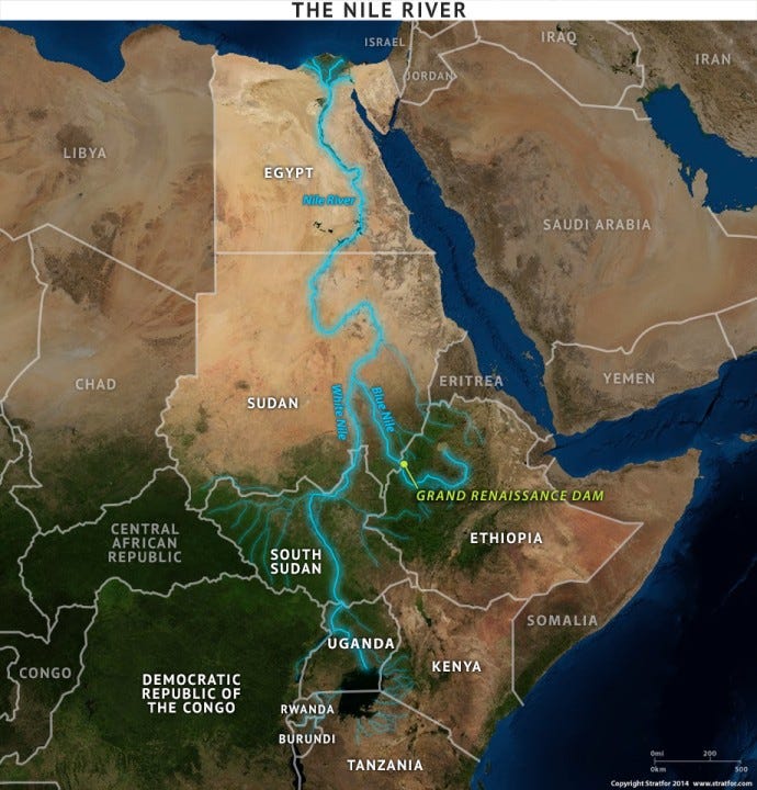
In The Heliocentric Model, The Nile River System Flows Uphill:
The Nile is a major north-flowing river in northeastern Africa. It flows into the Mediterranean Sea. The Nile is the longest river in Africa and has historically been considered the longest river in the world, though this has been contested by research suggesting that the Amazon River is slightly longer. Of the world's major rivers, the Nile is one of the smallest, as measured by annual flow in cubic meters of water. About 6,650 km (4,130 mi) long, its drainage basin covers eleven countries: the Democratic Republic of the Congo, Tanzania, Burundi, Rwanda, Uganda, Kenya, Ethiopia, Eritrea, South Sudan, Republic of the Sudan, and Egypt. In particular, the Nile is the primary water source of Egypt, Sudan and South Sudan.
Eric Dubay’s Commentary on The Nile River:
“One portion of the Nile River flows for a thousand miles with a fall of only one foot. Parts of the West African Congo, according to the supposed inclination and movement of the ball-Earth, would be sometimes running uphill and sometimes down. This would also be the case for the Parana, Paraguay and other long rivers.”
Heliocentrists Attempted To Debunk Eric Dubay’s Nile River Proof But Fail:
“Flat-Earthers often claim that if the Earth is spherical, then the Nile will have to flow uphill to overcome the curvature of the Earth. They are wrong. Water flows to a lower potential, or in other words to a lower level with respect to sea level. The Nile flows downhill to a level closer to sea level in its entire course. It empties to the Atlantic Ocean, which is the lowest potential along the Nile basin. Flat-Earthers think if the water in a small container forms a flat surface, then it must always be flat no matter how wide the surface is. They are wrong. The surface of water forms a spherical surface that has roughly the same distance to Earth’s center of gravity. It appears flat only because the curvature is minuscule in such small container.”
--Flat Earth Debunk Site
This is just the same ploy used again.
This attempt to debunk Dubay also fails because their model infers exactly what Dubay is saying…that 4,132 mile long Nile River is literally flowing uphill many miles over the Earth’s curvature. Again, water seeks its own level in a container, yes, but the 4,132 mile length of The Nile River adds an additional variable than that of the mere fundamental physical property of fluids finding and remaining level. The added variable of miles of curvature is in the equation, and Heliocentrists debunkers ignore this variable, again. Then, they throw the invisible Gravity variable into the equation to make it all work by magic instead of by science and logic.
Note:
In both instance, we are talking about hundreds and hundreds of miles of Earth Topography, not merely some higher and lower sea level “pocket” or Topological aberration in the Earth’s surface, and so, Earth curvature must being factored into the equation. What Heliocentrists are doing is applying a Flat Earth model when it comes to discussing sea level, and then inserting a curved Earth model with magic Gravity to make their uphill flow claim work.
The only claim helocentrism has re: gravity, is that all thing are pulled “IN” towards the center of the presupposed sphere earth. Any description of a “DOWNWARD” vector must be made with respect to a horizontal plane of reference. (Down, being 90° perpendicular to a horizontal plane.) There are no horizontal panes on a sphere either geometrically or observationally (meaning we do not observe sphericity or curvature at ALL. Ever.)
All elevations noted in your chart, are MEASURED with respect to their distance above or below sea LEVEL.
Actually... to even try to logically describe water moving up and over a sphere is a paradox.
Merry Christmas to you!! I really appreciate your articles and look forward to reading them.