


Captain Cook’s Antarctic Journey Proves Flat Earth

Captain Cook mapped the circumference of our 63,000 mile Antarctic Circle, thereby proving a Flat Earth. It took him and his crew 3 years, and 8 days to do so while mapping and naming landmarks along the way, only to have his research hidden and omitted form the ledgers of the modern educational (indoctrination) system.
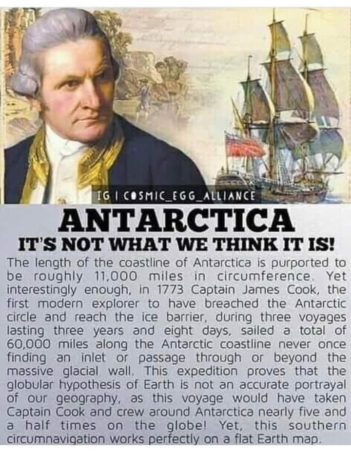
In 1773 Captain Cook became the first modern explorer known to have breached the Antarctic Circle and reached the ice barrier. During three voyages, lasting three years and eight days, Captain Cook and crew sailed a total of 63,000 miles along the Antarctic coastline, never once finding an inlet or path through or beyond the massive glacial wall. Cook circumvented The Earth only once in his epic 63,000 mile journey, but The Earth is supposed to be 24,000 miles in circumference. This speaks volumes.
Captain Cook wrote:
“The ice extended east and west far beyond the reach of our sight, while the southern half of the horizon was illuminated by rays of light which were reflected from the ice to a considerable height. It was indeed my opinion that this ice extends quite to the pole, or perhaps joins some land to which it has been fixed since creation.”
About Captain Cook:
Captain James Cook FRS (7 November 1728 – 14 February 1779) was a British explorer, cartographer and naval officer famous for his three voyages between 1768 and 1779 in the Pacific Ocean and to New Zealand and Australia in particular. He made detailed maps of Newfoundland prior to making three voyages to the Pacific, during which he achieved the first recorded European contact with the eastern coastline of Australia and the Hawaiian Islands, and the first recorded circumnavigation of New Zealand.
Cook joined the British merchant navy as a teenager and joined the Royal Navy in 1755. He saw action in the Seven Years' War and subsequently surveyed and mapped much of the entrance to the St. Lawrence River during the siege of Quebec, which brought him to the attention of the Admiralty and the Royal Society. This acclaim came at a crucial moment for the direction of British overseas exploration, and it led to his commission in 1768 as commander of HMS Endeavour for the first of three Pacific voyages.
In these voyages, Cook sailed thousands of miles across largely uncharted areas of The Earth. He mapped lands from New Zealand to Hawaii in the Pacific Ocean in greater detail and on a scale not previously charted by Western explorers. He surveyed and named features and recorded islands and coastlines on European maps for the first time. He displayed a combination of seamanship, superior surveying and cartographic skills, physical courage, and an ability to lead men in adverse conditions.
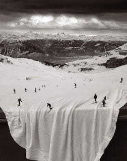
Nevertheless, The Earth is round and flat just like the scriptures states. The Sun is close and circles the Earth. Just point your smartphone on timelapse at The Sun and this irrefutably and unequivocally proves it. The spherical Earth was introduced by the Jesuits to discredit God and replace HIM with pseudoscience. NASA was formed in 1958 and the Antarctic treaty was signed in 1959. Spherical Earth is comical, convoluted, and nothing about it can be empirically demonstrated. It is all just propaganda bolstered up with CGI garbage and green screens. This propaganda is now a 400 billion dollar a year industry, subtextually interwoven to promote the shady Freemasons and their pathetic Luciferian and Sun worshipping Helios Cult. There is only one magnetic pole and it’s The North Pole. These facts are provable and demonstrable.
We are not living on a floating, spinning, wobbling spherical Earth, flying through an infinite vacuum void, while, oddly enough, never ever hitting anything. The Heliocentric Model is is a complete nonsensical fallacy which has no basis in observable reality.
Flat Earth - Captain Cook’s Antarctic Journey Proves Flat Earth:
The South Pole Does Not Exist: (From Eric Dubay)
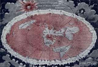
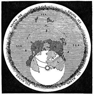
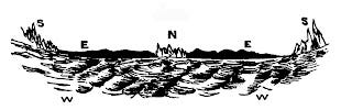
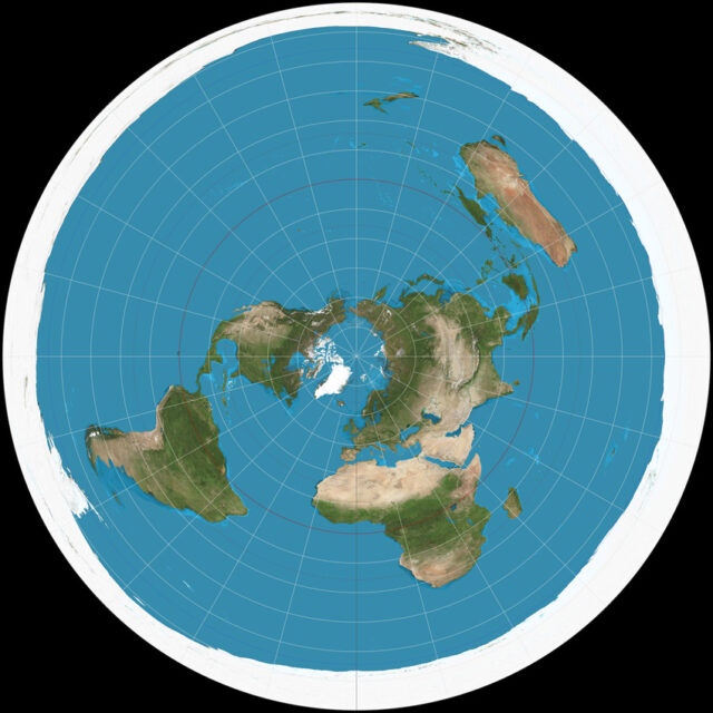
In the Flat-Earth model of the cosmos, the North Pole is the immovable center of the world and the entire universe. Polaris, the North Star, sits straight over the North Pole at the highest point in the heavens, and like a slowly rotating planetarium dome all the celestial bodies revolve around Polaris and over the Earth once per day. The Sun circles over and around the circumference of Earth every 24 hours, steadily traveling each day from the equator during the March vernal equinox, up to the Tropic of Cancer at the June summer solstice, back down to the equator for the September autumnal equinox, and all the way down to the Tropic of Capricorn on the December winter solstice.
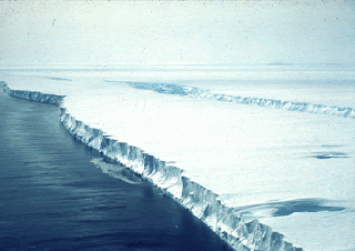
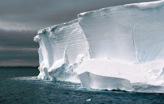
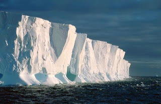
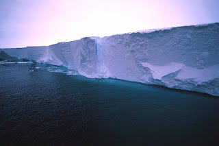
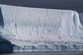
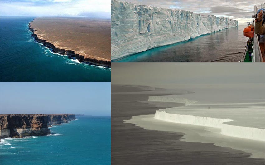
In the Flat-Earth model, the South Pole does not exist at all and Antarctica is instead a gigantic ice-wall extending the circumference of Earth holding in the oceans like a giant bowl, or a “world cup.” As strange as this concept may sound at first, it is a fact that if you set a bearing due South from anywhere on Earth, inevitably at or before 78 degrees Southern latitude, you will find yourself face-to-face with an enormous ice-wall towering 100-200 feet in the air extending to the East and West the entire circumference of the world.
“The ice-barrier, so frequently referred to in accounts of the Antarctic regions, is the fore-front of the enormous glacier-covering, or ice-cap, which, accumulating in vast, undulating fields from the heavy snowfall, and ultimately attaining hundreds, if not thousands, of feet in thickness, creeps from the continent of Antarctica into the polar sea. The ice-barrier, yet a part of the parent icecap, presents itself to the navigator who has boldness enough to approach its fearful front, as a solid, perpendicular wall of marble-like ice, ranging from one thousand to two thousand feet in thickness, of which from one hundred to two hundred feet rises above, and from eight hundred to eighteen hundred feet sinks below, the level of the sea." -Greely, General A. W. "Antarctica, or the Hypothetical Southern Continent." Cosmopolitan 17 (1894): p. 296
“It has been demonstrated that the earth is a plane, the surface-centre of which is immediately underneath the star called ‘Polaris,’ and the extremities of which are bounded by a vast region of ice and water and irregular masses of land. The whole terminates in fog and darkness, where snow and driving hail, piercing sleet and boisterous winds, howling storms, madly-mounting waves, and clashing icebergs are almost constant.” -Dr. Samuel Rowbotham, “Zetetic Astronomy, Earth Not a Globe!” (117)
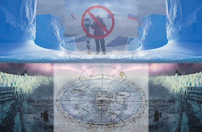
Antarctica is not the tiny “ice-continent” found confined to the underside antipode of astronomer’s globes. Quite the contrary, Antarctica literally surrounds us 360 degrees, encircles every continent, and acts as a barrier holding in the oceans. The most commonly asked questions, and the greatest mysteries yet to be solved are: how far does the Antarctic ice extend outwards? Is there a limit? What lies beyond, or is it just snow and ice forever? Thanks to U.N. treaties and constant military surveillance, the North Pole and Antarctica remain cloaked in government secrecy, both purported “no-fly/no-sail” zones, with several reports of civilian pilots and captains being shooed away and escorted back under threat of violence.
“How far the ice extends; how it terminates; and what exists beyond it, are questions to which no present human experience can reply. All we at present know is, that snow and hail, howling winds, and indescribable storms and hurricanes prevail; and that in every direction ‘human ingress is barred by unsealed escarpments of perpetual ice,’ extending farther than eye or telescope can penetrate, and becoming lost in gloom and darkness.” -Dr. Samuel Rowbotham, “Zetetic Astronomy, Earth Not a Globe!” (91)
Before reaching the Antarctic ice-wall, navigating the increasingly tumultuous Southern oceans, explorers encounter the longest, darkest, coldest nights and the most dangerous seas and storms anywhere on Earth. Vasco de Gama, an early 16th century Portuguese explorer of the South Seas wrote how, “The waves rise like mountains in height; ships are heaved up to the clouds, and apparently precipitated by circling whirlpools to the bed of the ocean. The winds are piercing cold, and so boisterous that the pilot’s voice can seldom be heard, whilst a dismal and almost continual darkness adds greatly to the danger.”

In 1773 Captain Cook became the first modern explorer known to have breached the Antarctic Circle and reached the ice barrier. During three voyages, lasting three years and eight days, Captain Cook and crew sailed a total of 60,000 miles along the Antarctic coastline never once finding an inlet or path through or beyond the massive glacial wall! Captain Cook wrote: “The ice extended east and west far beyond the reach of our sight, while the southern half of the horizon was illuminated by rays of light which were reflected from the ice to a considerable height. It was indeed my opinion that this ice extends quite to the pole, or perhaps joins some land to which it has been fixed since creation.”
On October 5th, 1839 another explorer, James Clark Ross began a series of Antarctic voyages lasting a total of 4 years and 5 months. Ross and his crew sailed two heavily armored warships thousands of miles, losing many men from hurricanes and icebergs, looking for an entry point beyond the southern glacial wall. Upon first confronting the massive barrier Captain Ross wrote of the wall, “extending from its eastern extreme point as far as the eye could discern to the eastward. It presented an extraordinary appearance, gradually increasing in height, as we got nearer to it, and proving at length to be a perpendicular cliff of ice, between one hundred and fifty feet and two hundred feet above the level of the sea, perfectly flat and level at the top, and without any fissures or promontories on its even seaward face. We might with equal chance of success try to sail through the cliffs of Dover, as to penetrate such a mass.”
“Yes, but we can circumnavigate the South easily enough,’ is often said by those who don't know, The British Ship Challenger recently completed the circuit of the Southern region - indirectly, to be sure - but she was three years about it, and traversed nearly 69,000 miles - a stretch long enough to have taken her six times round on the globular hypothesis.” -William Carpenter, “100 Proofs the Earth is Not a Globe” (78)
“If we now consider the fact that when we travel by land or sea, and from any part of the known world, in a direction towards the North polar star, we shall arrive at one and the same point, we are forced to the conclusion that what has hitherto been called the North Polar region, is really the center of the Earth. That from this northern center the land diverges and stretches out, of necessity, towards a circumference, which must now be called the Southern region: which is a vast circle, and not a pole or center … In this and other ways all the great navigators have been frustrated in their efforts, and have been more or less confounded in their attempts to sail round the Earth upon or beyond the Antarctic circle. But if the southern region is a pole or center, like the north, there would be little difficulty in circumnavigating it, for the distance round would be comparatively small. When it is seen that the Earth is not a sphere, but a plane, having only one center, the north; and that the south is the vast icy boundary of the world, the difficulties experienced by circumnavigators can be easily understood.” -Dr. Samuel Rowbotham, “Earth Not a Globe, 2nd Edition” (21-23)
If the Earth were truly a globe, then every line of latitude South of the equator would have to measure a gradually smaller and smaller circumference the farther South traveled. In other words, the circumference at 10 degrees South latitude would comprise a smaller circle than at the equator, 20 degrees South latitude would comprise a circle smaller than 10, and so on. If, however, the Earth is an extended plane, then every line of latitude South of the equator should measure a gradually larger and larger circumference the farther South traveled. 10 degrees South latitude will comprise a larger circle than the equator, 20 degrees South latitude will comprise a circle larger than 10, and so on. Likewise, if the Earth were a globe, lines of longitude would bubble out at the equator while converging at both poles. Whereas if the Earth is an extended plane, lines of longitude should simply expand straight outwards from the North Pole. So which is actually the case?
“Upon the principle, as taught by Scripture and common observation, that the world is not a Planet, but consists of vast masses of land stretched out upon level seas, the North being the centre of the system, it is evident that the degrees of longitude will gradually increase in width the whole way from the North centre to the icy boundary of the great Southern Circumference. In consequence of the difference between the actual extent of longitudes and that allowed for them by the Nautical Authorities, which difference, at the latitude of the Cape of Good Hope, has been estimated to amount to a great number of miles, many Ship-masters have lost their reckoning, and many vessels have been wrecked. Ship-captains, who have been educated in the globular theory, know not how to account for their getting so much out of their course in Southern latitudes, and generally put it down to currents; but this reason is futile, for although currents may exist, they do not usually run in opposite directions, and vessels are frequently wrecked, whether sailing East or West.” -David Wardlaw Scott, “Terra Firma” (102)
During Captain James Clark Ross’s voyages around the Antarctic circumference, he often wrote in his journal perplexed at how they routinely found themselves out of accordance with their charts, stating that they found themselves an average of 12-16 miles outside their reckoning every day, some days as much as 29 miles. Lieutenant Charles Wilkes commanded a United States Navy exploration expedition to the Antarctic from August 18th, 1838 to June 10th, 1842, almost four years spent “exploring and surveying the Southern ocean.” In his journals Lieutenant Wilkes also mentioned being consistently east of his reckoning, sometimes over 20 miles in less than 18 hours.
“The commanders of these various expeditions were, of course, with their education and belief in the earth's rotundity, unable to conceive of any other cause for the differences between log and chronometer results than the existence of currents. But one simple fact is entirely fatal to such an explanation, viz., that when the route taken is east or west the same results are experienced. The water of the southern region cannot be running in two opposite directions at the same time; and hence, although various local and variable currents have been noticed, they cannot be shown to be the cause of the discrepancies so generally observed in high southern latitudes between time and log results. The conclusion is one of necessity, forced upon us by the sum of the evidence collected that the degrees of longitude in any given southern latitude are larger than the degrees in any latitude nearer to the northern center; thus proving the already more than sufficiently demonstrated fact that the earth is a plane, having a northern center, in relation to which degrees of latitude are concentric, and from which degrees of longitude are diverging lines, continually increasing in their distance from each other as they are prolonged towards the great glacial southern circumference.” -Dr. Samuel Rowbotham, “Zetetic Astronomy: Earth Not a Globe!” (261)
“February 11th, 1822, at noon, in latitude 65.53. S. our chronometers gave 44 miles more westing than the log in three days. On 22nd of April (1822), in latitude 54.16. S. our longitude by chronometers was 46.49, and by D.R. (dead reckoning) 47° 11´: On 2nd May (1822), at noon, in latitude 53.46. S., our longitude by chronometers was 59° 27´, and by D.R. 61° 6´. October 14th, in latitude 58.6, longitude by chronometers 62° 46´, by account 65° 24´. In latitude 59.7. S., longitude by chronometers was 63° 28´, by account 66° 42´. In latitude 61.49. S., longitude by chronometers was 61° 53´, by account 66° 38´.” -Captain James Weddell, “Voyages Towards the South Pole”
“In the southern hemisphere, navigators to India have often fancied themselves east of the Cape when still west, and have been driven ashore on the African coast, which, according to their reckoning, lay behind them. This misfortune happened to a fine frigate, the Challenger, in 1845. How came Her Majesty’s Ship ‘Conqueror,’ to be lost? How have so many other noble vessels, perfectly sound, perfectly manned, perfectly navigated, been wrecked in calm weather, not only in dark night, or in a fog, but in broad daylight and sunshine - in the former case upon the coasts, in the latter, upon sunken rocks - from being ‘out of reckoning,’ under circumstances which until now, have baffled every satisfactory explanation.” -Rev. Thomas Milner, “Tour Through Creation”
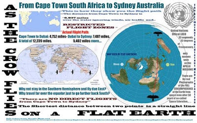
The equatorial circumference of the supposed ball-Earth is said to be 24,900 statute or 21,600 nautical miles. A nautical mile is the distance, following the supposed curvature of the Earth, from one minute of latitude to the next. A statue mile is the straight line distance between the two, not considering Earth’s alleged curvature.
The “Australian Handbook, Almanack, Shippers’ and Importers’ Directory” states that the distance between Sydney and Nelson is 1400 nautical or 1633 statute miles. Allowing a more than sufficient 83 miles as the distance for rounding Cape Farewell and sailing up Tasman Bay to Nelson leaves 1550 statute miles as the straight-line distance from the meridian of Sydney to the meridian of Nelson. Their given difference in longitude is 22 degrees 2’14”. Therefore if 22 degrees 2’14” out of 360 is 1550 miles, the entirety measures 25,182 miles. This is larger than the Earth is said to be at the equator, and 4262 miles greater than it would be at Sydney’s southern latitude on a globe of said proportions! One 360th part of 25,182 gives 70 miles as the distance between each degree of longitude at Sydney’s 34 degree Southern latitude. On a globe 25,000 miles in equatorial circumference, however, degrees of longitude at 34 degrees latitude would be only 58 miles, a full 12 miles per degree less than reality. This perfectly explains why Ross and other navigators in the deep South experienced 12+ mile daily discrepancies between their reckoning and reality, the farther South traveled the farther the divide.
“From near Cape Horn, Chile to Port Philip in Melbourne, Australia the distance is 9,000 miles. These two places are 143 degrees of longitude from each other. Therefore the whole extent of the Earth’s circumference is a mere arithmetical question. If 143 degrees make 9,000 miles, what will be the distance made by the whole 360 degrees into which the surface is divided? The answer is, 22,657 miles; or, 8357 miles more than the theory of rotundity would permit. It must be borne in mind, however, that the above distances are nautical measure, which, reduced to statute miles, gives the actual distance round the Southern region at a given latitude as 26,433 statute miles; or nearly 1,500 miles more than the largest circumference ever assigned to the Earth at the equator.” -Dr. Samuel Rowbotham, “Earth Not a Globe, 2nd Edition” (52)
Similar calculations made from the Cape of Good Hope, South Africa to Melbourne, Australia at an average latitude of 35.5 degrees South, have given an approximate figure of over 25,000 miles, which is again equal to or greater than the Earth’s supposed greatest circumference at the equator. Calculations from Sydney, Australia to Wellington, New Zealand at an average of 37.5 degrees South have given an approximate circumference of 25,500 miles, greater still! According to the ball-Earth theory, the circumference of the Earth at 37.5 degrees Southern latitude should be only 19,757 statute miles, almost six thousand miles less than such practical measurements.
“The above calculations are, as already stated, only proximate; but as liberal allowances have been made for irregularities of route, etc., they are sufficiently accurate to prove that the degrees of longitude, as we proceed south-wards, do not diminish, as they would upon a globe, but expand or increase, as they must if the earth is a plane; or, in other words, the farthest point, or greatest latitude south, must have the greatest circumference and degrees of longitude.” -Dr. Samuel Rowbotham, “Zetetic Astronomy: Earth Not a Globe!” (258)
“Parallels of latitude only - of all imaginary lines on the surface of the Earth - are circles, which increase, progressively, from the northern centre to the southern circumference. The mariner's course in the direction of any one of these concentric circles is his longitude, the degrees of which INCREASE to such an extent beyond the equator (going southwards) that hundreds of vessels have been wrecked because of the false idea created by the untruthfulness of the charts and the globular theory together, causing the sailor to be continually getting out of his reckoning. With a map of the Earth in its true form all difficulty is done away with, and ships may be conducted anywhere with perfect safety. This, then, is a very important practical proof that the Earth is not a globe.”
-William Carpenter, “100 Proofs the Earth is Not a Globe” (14)
Antarctica – The “Outer Space” Beyond the Ice Wall Surrounding Our World
“Strangely enough, there is an area left in the world today an area as big as the United States that’s never been seen by a human being.”
~Admiral Byrd

“Our journey begins with a man named Richard E. Byrd or more commonly known as Admiral Byrd. He was a highly decorated service member achieving the Medal of Honor and had an unquenchable thirst for exploring the unknown. This drive sent him to Antarctica numerous times, but the one expedition of interest is “Operation High Jump” (1946–1947). For this mission he was supported by the US Navy, giving him plenty of ships, boats, aircraft, and personnel to accomplish his goal. Well, he found something in Antarctica and in an interview gave an account of what he saw.
Here are a few quotes pulled from that interview, “Strangely enough, there is an area left in the world today an area as big as the United States that’s never been seen by a human being.” Byrd said he found this area as he moved further into Antarctica and even went on to say, “It’s an untouched reservoir of natural resources”. This isn’t the desolate wasteland of ice and snow that we typically think about when we imagine Antarctica, but according to the admiral if you travel far enough inland that is what you’ll see. Now unfortunately we cannot trust everything Byrd said as he was a Freemason, but it has been reported that he lost plane after plane due to some invisible barrier. Not too long after this started taking place did the expedition end, six months ahead of schedule mind you.“


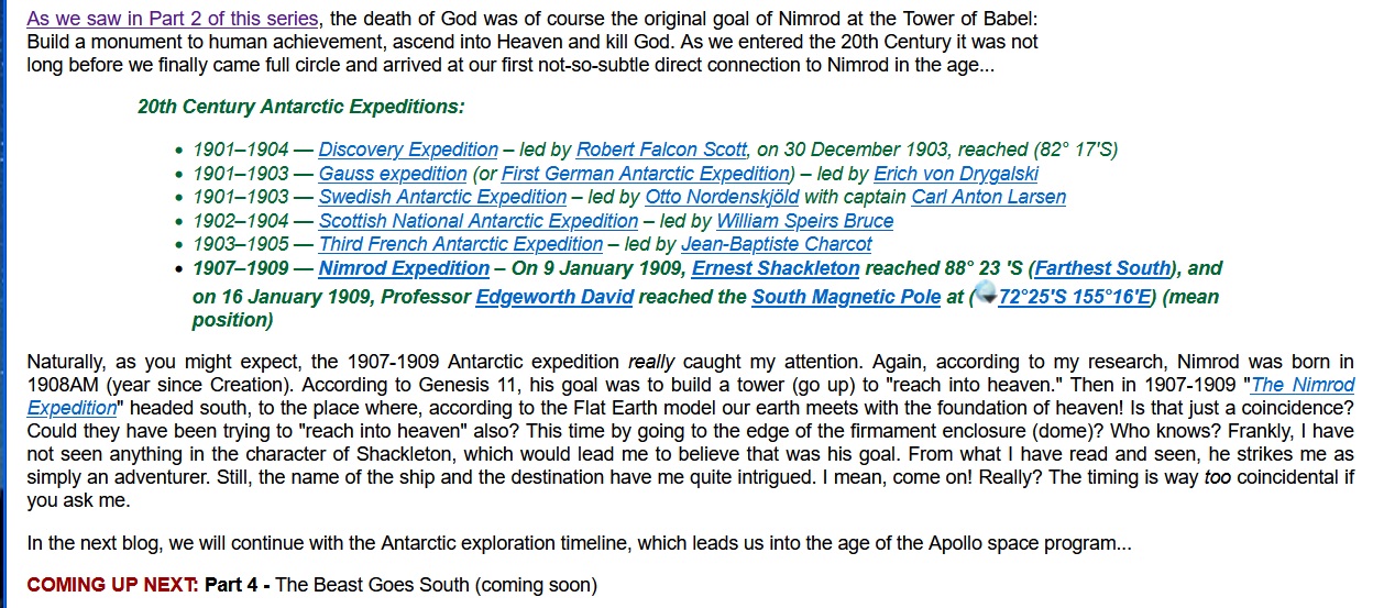
1908 – Nimrod Expedition (Secret Society Expedition?) – They Knew Something.
1946 – Operation High Jump – Discovery of the Ice Wall Rim/Shoreline of Our World Lake.
1955 – Operation Deep Freeze – Discovery of The Firmament
1958 – NASA Founded – Faking The Globe to Hide Biblical Earth
NASA – The Actor’s Guild of The Freemason Forked Tongue
Flat Earth Clues – Directors Cut – Mark Sargent – Under the Dome – They are hiding GOD
NASA’s Inconvenient Truth: It’s NOT Too Big a Conspiracy!
1962 – Operations Dominic (“of The Lord”) and Fishbowl (Together: Fishbowl of the Lord)
While I certainly understand man’s need for adventure into the unknown in search of answers and “new frontiers,” the more I look into this subject, it appears that Antarctica had been an obsession for quite some time. But prior to the advances of the mid-20th century, few actually made it there. It wasn’t until we were able to build better ships and the equipment needed to cut through the ice that such a trip was even possible. But why the big push for this “end of the earth” anyway? Could it be that man was after more than mere adventure and the discovery of new land? What if they were actually testing an ancient theory? What if they were trying to access Heaven through the ground floor door instead of the sky dome windows? What if the ultimate goal was to once again “reach into heaven” and… kill God? Sounds crazy? Let’s see…
Prior to the 20th Century AD, there were a number of expeditions to Antarctica worthy of note:
Pre-19th Century:
7th century — Ui-te-Rangiora claimed to have sighted southern ice fields.
13th century — Polynesians settle Auckland Islands (50° S)[1][2][3][4]
1501–1502 — Gonçalo Coelho and Amerigo Vespucci potentially sail to (52° S)
1522 — Ferdinand Magellan – first circumnavigation discovers Strait of Magellan (54° S)
1578 — Francis Drake discovers Drake Passage
1599 — Dirk Gerritsz – potentially sails to (64° S)
1603 — Gabriel de Castilla – potentially sails to (64° S)
1615 — Jacob le Maire and Willem Schouten first to sail around Cape Horn cross (56° S)
1619 — Garcia de Nodal expedition – circumnavigate Tierra del Fuego and discover Diego Ramirez Islands (
1675 — Anthony de la Roché discovers South Georgia (
54°15′00″S 36°45′00″W), the first ever land discovered south of the Antarctic Convergence
1698–1699 — Edmond Halley sails to (52° S)
1720 — Captain George Shelvocke – sails to (61° 30′ S)
1739 — Jean-Baptiste Charles Bouvet de Lozier – discovers Bouvet Island (
1771 — James Cook – HM Bark Endeavour expedition
1771–1772 — First French Antarctic Expedition – led by Yves-Joseph de Kerguelen-Trémarec discovers Kerguelen Islands (
1772–1775 — James Cook – sails HMS Resolution crossing Antarctic Circle in January 1773 and December 1773. On 30 January 1774 he reaches 71° 10′ S, his Farthest South, coming within about 75 miles of the Antarctic mainland without seeing it.
At this point, several people got close, but they still had not seen the mainland yet. Looking into the Cook expedition proved interesting though. Here are some intriguing quotes I recently found thanks to a Facebook friend pointing them out to me:
As for the Southern latitudes being larger than the North, they most certainly are and have shown to be so time and again. In 1773 Captain Cook became the first modern explorer known to have breached the Antarctic Circle and reached the ice barrier. During three voyages, lasting three years and eight days, Captain Cook and crew sailed a total of 60,000 miles along the Antarctic coastline never once finding an inlet or path through or beyond the massive glacial wall! Captain Cook wrote: “The ice extended east and west far beyond the reach of our sight, while the southern half of the horizon was illuminated by rays of light which were reflected from the ice to a considerable height. It was indeed my opinion that this ice extends quite to the pole, or perhaps joins some land to which it has been fixed since creation.”
On October 5th, 1839 another explorer, James Clark Ross began a series of Antarctic voyages lasting a total of 4 years and 5 months. Ross and his crew sailed two heavily armored warships thousands of miles, losing many men from hurricanes and icebergs, looking for an entry point beyond the southern glacial wall. Upon first confronting the massive barrier Captain Ross wrote of the wall, “extending from its eastern extreme point as far as the eye could discern to the eastward. It presented an extraordinary appearance, gradually increasing in height, as we got nearer to it, and proving at length to be a perpendicular cliff of ice, between one hundred and fifty feet and two hundred feet above the level of the sea, perfectly flat and level at the top, and without any fissures or promontories on its even seaward face. We might with equal chance of success try to sail through the cliffs of Dover, as to penetrate such a mass.”
Source: http://ifers.boards.net/thread/36/flat-earth-model?page=8&scrollTo=3353
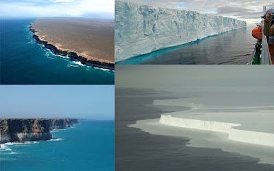
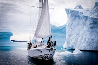
The earth is (allegedly) only 25,000 miles in circumference. Looking at a typical globe, Antarctica is about the same size as Australia. Yet, if the above article citation is true, why did it take Cook 60,000 miles to circumnavigate Antarctica? By the way, this is the “massive glacier wall” the article referred to -it is the coastline of Antarctica:
In the Flat Earther model, it forms the outer barrier, which would of course prevent anyone from “falling off the edge of the world.”
Antarctic expeditions really ramped up in 19th and 20th centuries, aided of course by advancements in technology and ship building.
Each of the following expeditions in the 19th Century provided exciting tales of exploration and the overcoming and failures that come from such adventures. Many of the names of Antarctica’s various features come from the expeditions listed below.
19th Century
1819 — William Smith discovers South Shetland Islands
62°00′S 058°00′W the first land discovered south of 60° south latitude.
1819 — San Telmo wrecks in the Drake Passage off Livingston Island
1819–1821 — Fabian Gottlieb von Bellingshausen – on 27 January 1820, discovers an ice shelf at Princess Martha Coast that later became known as the Fimbul Ice Shelf
1820 — Edward Bransfield with William Smith as his pilot – on 30 January 1820, sight Trinity Peninsula
63°37′S 058°20′W) – now the Antarctic Peninsula.
1820 — Nathaniel Palmer sights Antarctica on 17 November 1820
1821 — George Powell, a British sealer, and Nathaniel B. Palmer, an American sealer, discover the South Orkney Islands. Powell annexes them for the British.
1821 — John Davis – on 7 February 1821 disputed claim of setting foot on Antarctica at Hughes Bay
1823–1824 — James Weddell discovers the Weddell Sea; – on 20 February 1823 his ship Jane (160 tons) reached a new Farthest South of 74° 15′ S
1830–1833 — Southern Ocean Expedition led by John Biscoe, an English sealer; circumnavigates the continent, sets foot on Anvers Island, names and annexes Graham Land, discovers Biscoe Islands, Queen Adelaide Island
67.25°S 68.5°W and sights Enderby Land
1837–1840 — Second French Antarctic Expedition – led by Jules Dumont d’Urville; discovers Adelie Land and sets foot on an islet of Geologie Archipelago
66°36′19″S 140°4′0″E) 4 km from the mainland to take mineral and animal samples (66° S)
1838–1839 — John Balleny discovers Balleny Islands
1838–1842 — United States Exploring Expedition – led by Charles Wilkes to Antarctic Peninsula
69°30′S 065°00′W) and eastern Antarctica; discovers “Termination Barrier” (“Shackleton Ice Shelf”)
1839–1843 — James Clark Ross discovered the Ross Ice Shelf, Ross Sea, Mount Erebus, Mount Terror and Victoria Land; extended his Farthest South to 78° 10′ S on 23 January 1842
Meanwhile, at a time when the Holy Spirit inspired truths of Scripture were being tossed out in favor of the wild imaginations of flawed “men of science” who began to think of themselves as evolved apes, which themselves were the product of countless mutations, resulting from the adaptation of things evolved from some sort of primordial ooze, which suddenly came to life having been spawned out of a lifeless slime pit millions/billions of years prior, the expeditions to Antarctica continued…
1872–1876 — HMS Challenger under Capt. George S. Nares, becomes the first steamship to cross the Antarctic Circle; reopens the study of oceanography in the region after a 30-year gap.
1892–1893 — Carl Anton Larsen led the first Norwegian expedition to Antarctica aboard the ship Jason. Larsen became the first person to ski in Antarctica where the Larsen Ice Shelf was named after him.
1892–1893 — Dundee Whaling Expedition discover Dundee Island
1893–1894 — Carl Anton Larsen led the second Norwegian expedition to Antarctica
1893–1895 — Henryk Bull, Carstens Borchgrevink and Alexander von Tunzelmann – set foot on Antarctica at Cape Adare
1897–1899 — Belgian Antarctic Expedition – led by Adrien de Gerlache; first to winter in Antarctica
1898–1900 — Southern Cross Expedition, Carsten Borchgrevink – sails to Cape Adare, winters on Antarctica and takes Farthest South on 16 February 1900 at 78° 50′
While Antarctica expeditions were beginning to become more and more prevalent (possibly in an effort to prove this up-and-coming new Godless paradigm of evolution over millions/billions of years), a remnant of Godly men rose up in opposition – namely, Dr. Samuel B. Rowbotham, William Carpenter and David Wardlaw Scott.
Flash Frozen by the Falling Flood Waters
Related:
SCIENTISM – The Cult of False Sciences
Antarctica and The Piri Reis Maps
Hollow Earth Entrance #2 – Antarctica
Hollow Earth – What Lies Beneath Us
Britain’s Secret War in Antarctica (part 1)
Britain’s Secret War in Antarctica (part 2)
Britain’s Secret War in Antarctica (part 3)
The Fallen Angels Imprisoned in Antarctica and are still Alive!
Never-Before-Seen Footage Uncovers Antarctica’s First Scientific Missions
Nimrod, the Tower (it WAS about height), the Beast, Antarctica and Flat Earth
Third Reich – Operation UFO (Nazi Base In Antarctica) Complete Documentary
Gearing Up For Apollo: Part1: Architects of a Spherical World
Gearing Up For Apollo: PART 2: Examining An Ancient Motive
Gearing Up For Apollo: PART 3: A Time of Great Change… And The Death of God
Flatten The Curve – The Documentary
Antarctic Giants 1 – Multiple Unheard Stories…
Antarctic Giants 2: Antonio Pigafetta’s Full Account, Chronicler Of Magellan’s Voyage In 1519
Mt. Meru At The North Pole: Mercator To John Dee, 1577
The Policy Of Blood And Mysticism
Biblical Earth Topics:
Biblical Earth – Young, Stationary, Geocentric, Flat & Domed
Debunking Flat Earth 101 (full version)
Debunking Flat Earth 101 (Short Version)
Cool! Check out at what Blue Origin’s Shepard Flight proved!
World Upside Down (Biblical EARTH Documentary 2022)
Biblical Earth Cosmology – FAQ
Skydome: The Firmly Solid Firmament
NASA – The Actor’s Guild of The Freemason Forked Tongue
Enoch, Nimrod, Admiral Byrd, Flat Earth and a Most Peculiar Timeline
Secret Space Program Disclosure and the Vril Society – ROBERT SEPEHR
Flat Earth Clues – Directors Cut – Mark Sargent – Under the Dome – They are hiding GOD
NASA’s Inconvenient Truth: It’s NOT Too Big a Conspiracy!
Hidden History: They are Hiding God, the Firmament, & The Seed War (/w Guest Mark Sargent)
Zetetic astronomy. Earth not a globe! an experimental inquiry into the true figure of the earth
One hundred proofs that the earth is not a globe
Terra firma : the earth not a planet, proved from scripture, reason and fact
The History of Flat Biblical Earth
Astrology Proves Earth Is Stationary and the Center Of Creation: Astro Tulum Event
Biblical Earth – The Atlantis Survivors Conspiracy – Part 2
Debunking # 1 of the “Top Ten Reasons Why We (allegedly) Know the Earth is Round (SHORT VERSION)
Debunking # 2 of the “Top Ten Reasons Why We (allegedly) Know the Earth is Round (as in a globe)
Debunking # 3 of the “Top Ten Reasons Why We (allegedly) Know the Earth is Round (as in a globe)
Debunking # 4 of the “Top Ten Reasons Why We (allegedly) Know the Earth is a Globe + A CHALLENGE
Debunking # 5 of the “Top Ten Reasons Why We (allegedly) Know the Earth is Round (as in a globe)
Debunking # 6 of the “Top Ten Reasons Why We (allegedly) Know the Earth is Round (as in a globe)
Debunking # 7 of the “Top Ten Reasons Why We (allegedly) Know the Earth is Round (as in a globe)
Debunking # 8 of the “Top Ten Reasons Why We (allegedly) Know the Earth is Round (as in a globe)
Debunking # 9 of the “Top Ten Reasons Why We (allegedly) Know the Earth is Round (as in a globe)
Debunking # 10 of the “Top Ten Reasons Why We (allegedly) Know the Earth is Round (as in a globe)
Enoch’s Pillar Supported Dome World and the Bible
The Bible and the Still Flat Earth
Has an Ancient AE Circular Flat Earth Map Just Been Discovered?
Enoch, the Bible, Flat Earth and Captain Kirk
TFR – 27 – Revolutionary Radio Project with Mark Sargent: Enclosed Earth Theory
How Pythagoras and Eratosthenes gave us THE Flat Earth trump card
The Genesis Revelation: Part 1 – The Biblical Flat Earth?
Is the spinning globe model the “Strong Delusion” of Scripture?
Search: Biblical Earth
Rob Skiba proves the Chicago skyline (as seen from the other side) is NOT a mirage
William Ramsey Investigates Flat Earth w David Weiss (Debate w/ Skeptic)
Sacred Word Revealed 2020 Conference – The Firmament with Rob Skiba
The indisputable Biblical case for a Flat Earth cosmology
Debunking the “Top 10 Reasons We Know the Earth is a Globe” (Condensed)
BEST SPACE FAILS IN ONE VIDEO!
Operation Fishbowl of the Lord (Dominic+Fishbowl) – 1962
SCIENTISM – The Cult of False Sciences
FREEMASON PRISON: Hollywood, Music, Sports, Space, War, Politics
Did It Really Happen? A Deeper Look Into The Space Shuttle Challenger Disaster.
Antarctica – The “Outer Space” Beyond the Ice Wall Surrounding Our World
Biblical Earth – Young, Stationary, Geocentric, Flat, Hollow & Domed
Thank you very much for writing about biblical cosmology. The truth has been hidden for so long and it's wonderful to see more people come to the knowledge of God and how he created our world. Keep speaking the truth and God bless!